Digital Mountain and Remote Sensing Applications Center of IMHE investigated quake zone (Taiping Town, Baosheng Town, Longmen Town) by means of remote sensing image.
According to image interpretation, 85.2% of houses in the investigated area were damaged seriously, and 20.7% of these houses completely were broken down. The investigation found 482 geological disasters including landslide and collapses total, and collapse area accounts for around 0.6% of the investigated area. It seems that Lushan disaster situation was less severe than Wenchuan earthquake. Among the three investigated quake zone, Longmen town was the worst-hit district by the quake. 87% houses were damaged and 22% of these houses completely broken down. About 187 geological disasters including landslide and collapses were found in Baosheng Town, the collapse area accounts for around 1.23% of the investigated area. However, there is no huge landslide disaster until now.
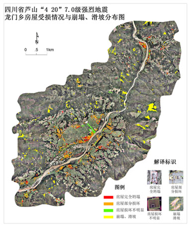
Damage situation in Longmen Town. (Picture taken by Sichuan Administratinof Surveying, Mapping and Geoinformation)
This remote sensing investigation mainly focused on the core area of epicenter. The seismic intensity of Lushan quake reached to 9 degree. The intensity decreased with the hypocenter outward, and the damage was reduced then.
Based on the analysis, the houses of core area were damage seriously, especially the houses in countryside were damaged much more seriously than in township. The landslide and collapse caused by quake was a big problem. Furthermore, the highway was frequent blocked by rock and collapse under the impact of aftershock, which makes it hard to rescue people’s life and properties.