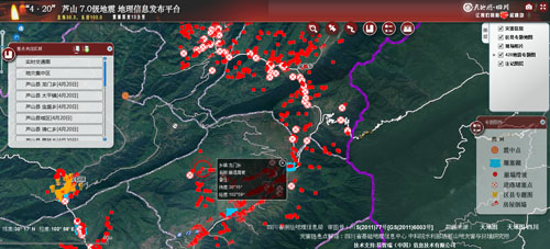
The remote sensing image interpretation of quake zone has been finished jointly by Institute of Mountain Hazard and Environment (IMHE), CAS, and Geomatics Center of Sichuan Province.
Experts recognized and extracted the potential sites of geo-hazard in quake zone, and uploaded the files to Geo-Information Platform of Lushan Earthquake, which offered technical support to disaster relief and rebuilt work.
Up to 16:00 pm of April 23, experts found a total of 863 geological disasters, including 3 dammed lakes, 355 collapses and landslides, 61 blocked roads, 264 houses collapsed and 180 houses damaged. Among those, there are 75 collapses and landslides, 24 blocked roads, and 29 houses collapsed in Taiping Town. In Longmen Town, there are 2 dammed lakes, 10 collapses and landslides, 71 blocked roads, and 97 houses collapsed. In Lushan County, there are 2 blocked roads, 8 houses collapsed and 2 houses damaged. In Qingren Town, there are 1 collapse and landslide and 41 houses collapsed. In Siyan Town, there are 2 houses collapsed. In Shangli Town, there are 74 houses collapsed and 93 houses damaged. In Xinhua Town, there is 1 housed collapsed. In Shuangshi Town, there are 1 damned lake, 22 collapses and landslides, 1 blocked road, 9 houses collapsed and 83 houses damaged.

Geo-Information Platform of Lushan Earthquake
Now, the data is being updated further by experts. The public may use the Geo-Information Platform of Lushan Earthquake to check into the high resolution image and disaster sites of quake zone.
To visit Geo-Information Platform of Lushan Earthquake, please click: http://www.scgis.net/LSXEarthquake/
