Land surface soil moisture (SSM) is a key variable that partly controls the energy and mass exchanges between the land surface and near-surface atmosphere, as well as the partitioning of surface net energy into latent and sensible heat fluxes. It has been identified as one of the 16 terrestrial essential climate variables by the Global Climate Observing System. Therefore, accurately determining the status of SSM and its dynamics is becoming increasingly important in hydrological, ecological, agricultural, and global change studies.
Technically, ground measurements, numerical model simulations, and remote sensing estimations are the major ways of estimating the spatiotemporal distribution of SSM. However, due to the impacts of the variations in surface vegetation cover, vegetation type, soil properties, rainfall events, topography, and so on, SSM usually exhibits high spatiotemporal heterogeneity, which is characterized by small- and large-scale variability as well as short- and long-term processes within the system. Thus, the point-based ground measurements have poor spatial representativeness, and remote sensing provides the opportunity to retrieve SSM at the regional to global scale. Among the remote sensing methods, the passive microwave remote sensing method has good advantage than the thermal infrared method due to its direct relationship to SSM. However, all its products have a common characteristic of coarse spatial resolution (which is on the order of approximately tens of kilometers). Although these coarse resolution products are sufficient for global applications, they are not applicable for regional studies that require higher spatial resolution products demanded from 1 to 10 km.
To overcome this disadvantage, a major solution is disaggregating the coarse resolution soil moisture product to a higher resolution scale with the use of optical and thermal infrared remote sensing data. In this downscaling algorithm, the relationship model used to present the connection between SSM and other surface variables is the most important one, which directly determines the downscaling accuracy. Under this background, Dr. ZHAO Wei and his research group recently have conducted a systematic analysis study to evaluate the performance of the commonly used relationship model with high resolution remote sensing data from NASA Landsat-8 and different soil moisture observation networks in the world. In this study, they explained the different performances of the models in accurately estimating SSM with different vegetation indices and model structures. In addition, they introduced the use of water index to enhance the relationship and improve the estimation results.
Moreover, the research group promoted the use of machine learning method (random forest regression) to express the relationship between SSM and other surface variables (land surface temperature, vegetation index, water index, surface albedo, and elevation), and the accuracy had a large improvement. The relationship model was successfully applied to the downscaling study with satellite observations from MODIS and SMAP. The result indicated that the downscaled SSM had a consistent spatial distribution pattern with the original SMAP SSM product and the downscaled SSM had an obvious improvement in accuracy according to the validation with in-situ measurements.
Generally, the above-mentioned studies are the fundamental research focusing on SSM estimation and spatial scale transferring. The methods must be helpful for regional SSM mapping and the estimation for mountainous areas.
These studies have been supported by National Natural Science Foundation (41771409, 41631180, and 41401425), and the Youth Innovation Promotion Association CAS.
The study entitled Performance Evaluation of the Triangle-Based Empirical Soil Moisture Relationship Models Based on Landsat-5 TM Data and In Situ Measurements has been published online in IEEE Transaction on Geoscience and Remote Sensing, the study entitled Potential of Estimating Surface Soil Moisture With the Triangle-Based Empirical Relationship Model has been published online in IEEE Transaction on Geoscience and Remote Sensing and the study entitled A spatial downscaling approach for the SMAP passive surface soil moisture product using random forest regression has been published online in Journal of Hydrology.

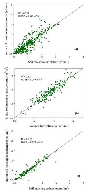
Figure 1. Surface soil moisture estimation results with traditional model (left column) and its improvement (right column) (Image by ZHAO Wei).

Figure 2. Downscaling results of the SMAP surface soil moisture product with the proposed method (Image by ZHAO Wei).
Contact:
Prof. ZHAO Wei
Institute of Mountain Hazards and Environment, Chinese Academy of Sciences
Chengdu, Sichuan, 610041, China
Tel: 86-13408515895
E-mail: zhaow@imde.ac.cn