Debris flows occur frequently and cause considerable damage in the Wenchuan Earthquake area. As the foundation for both early warning system building and scientific research, monitoring are of significance and be emphasized by both government and research institute. A dense monitoring network comprising rain gauges and flow depth instruments was established after the Wenchuan Earthquake, however, there is no practical monitoring output presented due to the deficiencies and difficulties, especially in terms of monitoring strategy.
A series of monitoring works have been carried out by Prof. CUI Peng and his team since 2013. The systems were expected to facilitate investigation of the spatial variation of rainfall and identification of the thresholds for debris flows, as well as record hydrographs on different basin scales and reveal flow properties. Taking a watershed named Ergou with a 39.4 km2 area, in which the frequency of occurrence of debris flows is high, as an example, the monitoring system and output were presented. The debris flow events were categorized and the general runoff velocity, discharge, and density were analyzed. The empirical methods for estimating the velocity and the total volume of debris flows based on other easily obtainable parameters, e.g., maximum flow depth and duration. Comparison of the results derived using the monitoring data and empirical formulas with those obtained in other small watersheds worldwide revealed the debris flow characteristics in this relatively large watershed. Rainfall threshold for the debris flows was proposed, which is higher than those proposed for the same region for periods shortly after the Wenchuan Earthquake (2008–2013), and the temporal evolution of the rainfall conditions necessary for debris flows was addressed.
It is worth mentioned that besides Ergou, two other sites called Longxi River in Dujiangyan City and Jiyu Gully in Mao County, both in the Wenchuan Earthquake hit area were also well constructed and will provide valuable monitoring data for scientific research.
This study have lasted 6 years and has been supported continuously by Key Deployment Project of Chinese Academy of Sciences (Grant No. KZZD-EW-05-01) , National Key Technologies R&D Program of China (Grant No. 2012BAK10B04), Sichuan Science and Technology Support Plan (2014SZ0163), and Youth Innovation Promotion Association, CAS.
This study entitled Real-time observation of an active debris flow watershed in the Wenchuan Earthquake area has been published online in Geomorphology.
.

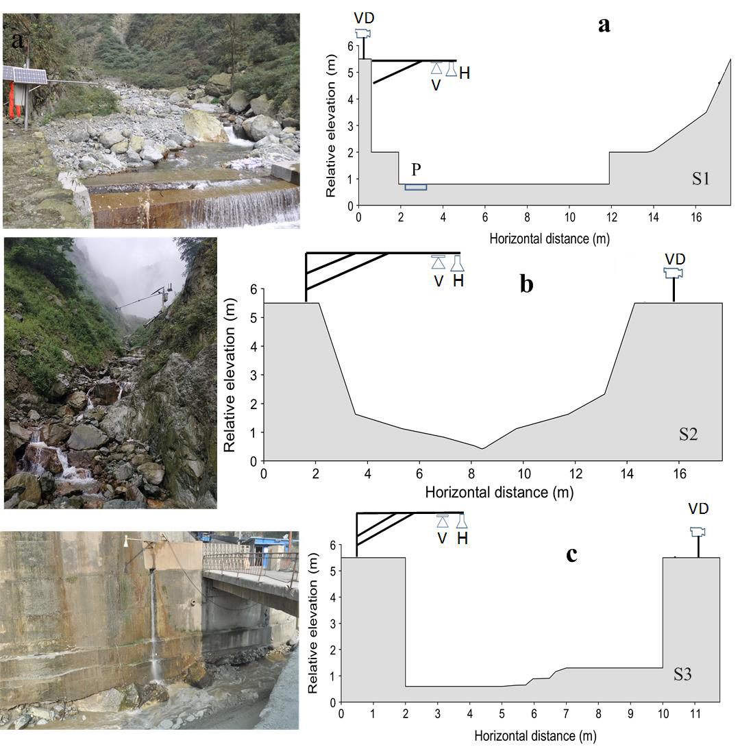
Figure 1. Geometries of the monitoring sections (S1–S3) showing the layouts of instruments. a: S1, b: S2 and c: S3. VD denotes video cameras, respectively. H = flow depth device, V = flow velocity device and P = piezometer force device, for measuring the flow vertical pressure (Image by GUO Xiaojun).

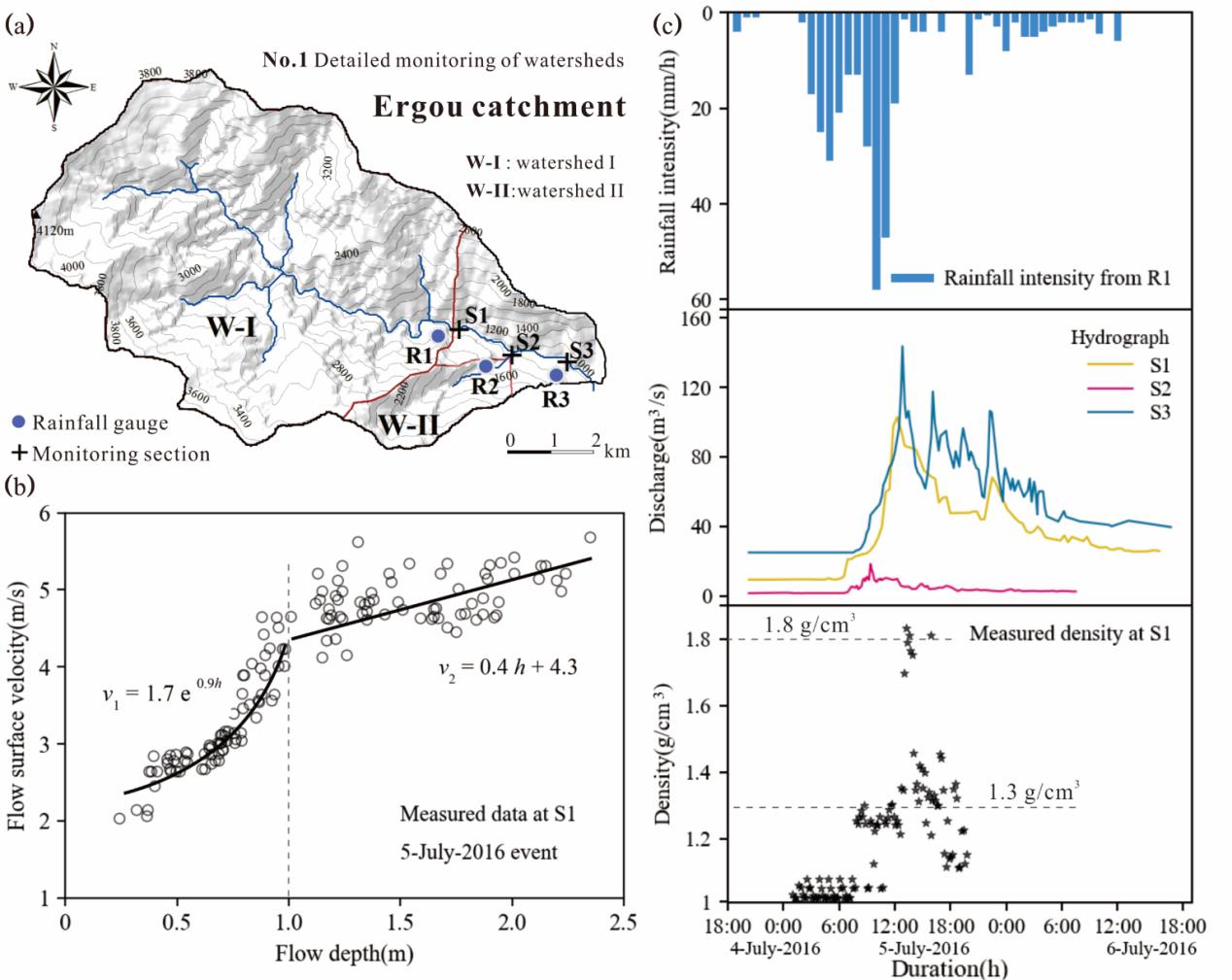
Figure 2. Data analysis of the debris flow which occurred on 5 July 2016 in Ergou: (a) Map of the catchment; (b) Flow surface velocity vs flow depth; (c) rainfall, flow discharge and flow density (Image by GUO Xiaojun).
Contact:
Dr. GUO Xiaojun
Institute of Mountain Hazards and Environment, Chinese Academy of Sciences
Chengdu, Sichuan, 610041, China
Tel: 86-13980665946
E-mail: aaronguo@imde.ac.cn
