In Bangladesh, the study of flood risk management and emergency evacuation is at an early stage. Many governmental, non-governmental, international, private, and volunteer organizations are involved with the emergency functions like dissemination of flood warning, evacuation, and relief operation among the flood victims. However, in most emergency rehabilitation programs, the operational team is unable to reach affected areas in due time because of lack of appropriate information. Moreover, the location of the emergency evacuation centers (EECs) is generally unknown and emergency management finds it very difficult to transfer potential flood victims to appropriate EECs during floods, especially in the areas having lack of flood control. To support effective flood management planning in Bangladesh, Prof. CHEN Ningsheng, Mahfuzur RAHMAN (PhD candidate) from Institute of Mountain Hazards and Environment, Chinese Academy of Sciences (IMHE, CAS), and Prof. Md Monirul ISLAM from International University of Business Agriculture and Technology (IUBAT) conducted a research to develop an evacuation system. This is the first-hand work to suggest optimization process of regional-scale emergency planning, in the context of disaster preparedness and recovery response.
The results showed that existing EECs were not optimally distributed, and that some areas were not adequately served by EECs (i.e., not all demand points could be reached within a 60-minute travel time). Keeping in mind the objective of the study, an optimized MCLP model was applied to select the optimal distribution of EECs across the study area and redistribute the existing EECs to ensure a better coverage of demand points. Finally, the results showed that 47.88% of demands points could be reached within a travel distance of 10 minutes to serve the flood-affected people while the previous analysis showed a coverage of 28.18%. This percentage increases when the impedance cutoff is increased for redistribution of EECs along with new EECs. The 60 minutes impedance cutoff showed the maximum demand points (62,147 out of 62,147 demand points). We concluded that the proposed models can be used to improve planning of the distribution of EECs, and that application of the models could contribute to reducing human casualties, property losses, and improve emergency operation.
This research was supported by the National Natural Science Foundation of China (Grant Nos. 41861134008 and 41671112) and the 135 Strategic Program of the Institute of Mountain Hazards and Environment (IMHE), Chinese Academy of Sciences (CAS) (Grant No. SDS-135-1705). The research titled Location-allocation modeling for emergency evacuation planning with GIS and remote sensing: A case study of Northeast Bangladesh has been published online in Geoscience Frontiers.
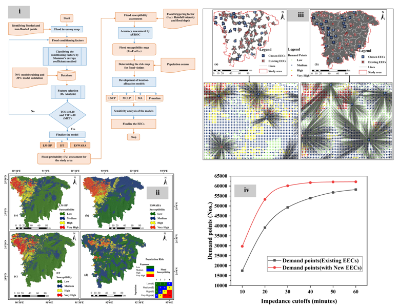
Figure . (i) Workflow of the study, (ii) population risk map, (iii) the results of the optimized MCLP model, and (iv) comparison of the results (Image by CHEN Ningsheng).
Contact:
Prof. CHEN Ningsheng
Institute of Mountain Hazards and Environment, Chinese Academy of Sciences
Chengdu, Sichuan, 610041, China
Tel: 86-13808171963
E-mail: chennsh@imde.ac.cn