The geographical setting and seasonal climate of Bangladesh significantly impact the flooding processes. During the monsoon, the southern Himalayas experience flooding almost every year, along with significant damage. In general, four types of floods can be distinguished, i.e., fluvial or monsoon (riverine) floods, flash (rainwater) floods, pluvial or urban floods, and tidal surges or coastal floods. However, multi-type flood risk management and hazard mapping have not yet been comprehensively examined at the national scale. Keeping view this in mind, this study addresses the following research questions: (i) What are the explanatory factors associated with multi-type floods in Bangladesh? (ii) Do stacking hybrid EMLAs perform better than standalone EMLAs in multi-type flood probability mapping? To address these questions, we aimed to: (i) compare hybrid EMLAs with standalone ensemble algorithms, and (ii) test the sensitivity of explanatory factors that contribute to flooding. Specifically, this study compares locally weighted linear regression, random subspace, reduced error pruning tree, random forests, and M5-Pruned model tree algorithms and their stacking hybrid ensembles (LWLR-RSS, LWLR-REPTree, LWLR-RF, and LWLR-M5P). To the best of authors knowledge, this the first application of stacking hybrid algorithms in the prediction of national-scale multi-type floods, offering a more accurate tool for developing flood probability maps that can support flood risk management policies. This study was designed by Prof. CHEN Ningsheng, Assistant Prof. Dr. Mahfuzur Rahman from Institute of Mountain Hazards and Environment, Chinese Academy of Sciences (IMHE, CAS), and Prof. Dr. Md. Monirul Islam from International University of Business Agriculture and Technology (IUBAT), Bangladesh.
In addition to the individual algorithms, this study employed a stacking hybrid algorithm for multi-floods modeling for the first time. This study adopted the stacking algorithm, which is an ensemble algorithm that combines multiple algorithms (regression or multi-classifications) during the training phase. Stacking hybrid algorithms can enhance predictive capability compared to bagging and boosting algorithms. The basic concept of a stacking hybrid algorithm is to train and predict the initial training dataset via first-level learners (Fig 1). The prediction results (from first-level learners) were merged to prepare a new training dataset for the meta-learner.
The relevant authorities could use multi-type flood probability maps to identify and prioritize areas susceptible to different flood hazards. This approach can streamline decision-making with respect to flood countermeasures. Furthermore, the proposed approach can be applied to quickly and efficiently generate flood probability maps for data-sparse areas. Mapping outputs could be coupled with hydrodynamic models to better predict and ascertain flood risks. Besides, other countries with similar topography and environmental conditions can use these algorithms to identify flood susceptible area. Lastly, this approach could also be developed further for the probability mapping of other environmental disasters such as landslides, debris flows, snow avalanches, gully erosion, and land subsidence.
This work was supported by the National Natural Science Foundation of China (Grant no. 41861134008), the Second Tibetan Plateau Scientific Expedition and Research Program (STEP) of China (Grant no. 2019QZKK0902), the National Key Research and Development Program of China (Project no. 2018YFC1505202), and the Key R&D Projects of Sichuan Science and Technology (Grant no. 18ZDYF0329). The research titled “Application of stacking hybrid machine learning algorithms in delineating multi-type flooding in Bangladesh” has been published online in Journal of Environmental Management (Q2 Top, IF=6.789).
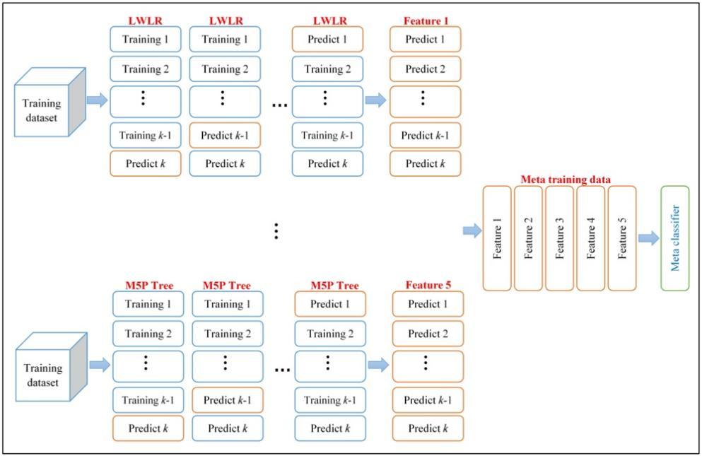
Fig. 1 Flow chart of stacking hybrid algorithm construction (Image by Dr. Mahfuzur Rahman).
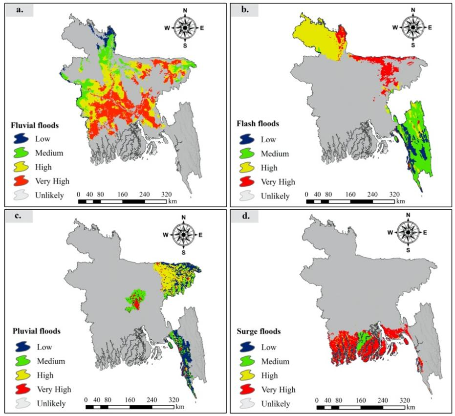
Fig. 2 Flood probability maps constructed from the stacking LWLR-RF algorithm: (a) fluvial floods, (b) flash floods, (c) pluvial floods, and (d) surge floods (Image by Dr. Mahfuzur Rahman).
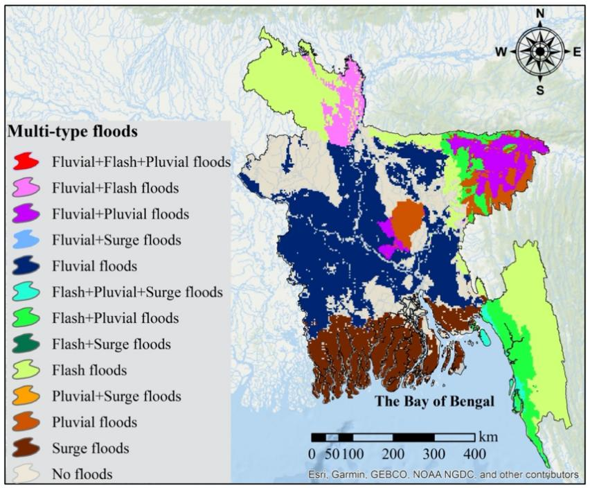
Fig. 3 Multi-type flood probability map constructed using the stacking LWLR-RF algorithm combining four single-type flood probability maps (Image by Dr. Mahfuzur Rahman).
Contact:
Prof. CHEN Ningsheng
Institute of Mountain Hazards and Environment, Chinese Academy of Sciences
Chengdu, Sichuan, 610041, China
Tel: 86-13808171963
E-mail: chennsh@imde.ac.cn