
Accurately obtaining the location, crown width, tree height, and forest type of each individual tree is fundamental to forest resource inventory, carbon stock assessment, and biodiversity conservation. It is also critical information for constructing realistic 3D forest scenes and digital twins in mountainous regions. However, complex mountain forests—characterized by rugged terrain, severe crown occlusion, and adhesion—pose great challenges for accurate individual tree segmentation (ITS). Existing methods for extracting individual tree attributes (ITAE) typically model each attribute separately, lacking information sharing among tasks and making it difficult to generate a comprehensive individual-tree attribute database to support mountain digital twins. To address these issues, the research team on Mountain Quantitative Remote Sensing and Digital Twins at the Institute of Mountain Hazards and Environment, Chinese Academy of Sciences (IMHE, CAS), has proposed a deep learning-based method for individual tree segmentation and multi-dimensional attribute extraction in mountain forests. This method integrates deep learning, traditional image processing, and knowledge transfer techniques to synergistically obtain information on individual tree location, crown width, tree height, and forest type. It provides fine-scale data support for constructing realistic mountain forest scenes and digital twins, and promotes the transformation of mountain forest remote sensing monitoring from stand-scale to individual-tree-scale, and from single-attribute retrieval to collaborative multi-dimensional attribute extraction.
The study was conducted in a 5 km × 5 km typical mountain forest area within the Wanglang National Nature Reserve, using UAV RGB imagery at 0.2 m spatial resolution and UAV LiDAR data from representative sample plots. A multi-task collaborative framework for ITS and ITAE was constructed. The framework first combines a U‑Net++ model with a self‑attention mechanism and a marker‑controlled watershed algorithm to form a two‑stage ITS method—"deep learning‑based preliminary segmentation followed by watershed‑based fine segmentation." Subsequently, sequential transfer learning is employed to transfer the semantic features of crown boundaries, textures, and spatial structures learned from the segmentation task to tree height prediction and forest type classification tasks, enabling the collaborative extraction of individual tree location, crown width, tree height, and forest type.
Results show that the two‑stage ITS method effectively reduces under‑segmentation caused by crown occlusion and adhesion. Compared with using the deep learning model alone, the omission rate decreased from 9.12% to 4.67%, and the F1‑score improved from 0.9298 to 0.9537; the RMSE of crown width estimation was 0.4307 m. Sequential transfer learning significantly improved the prediction of individual‑tree attributes: the RMSE of tree height prediction decreased from 7.1504 m to 3.4825 m, and the overall accuracy of forest type classification increased from 81.68% to 92.51%. The study ultimately identified 290,192 individual trees across the experimental area and generated an integrated spatial dataset containing individual tree location, crown width, tree height, and forest type. The results can support the construction of 3D realistic scenes and digital twins of mountain forests, and serve forest resource inventory, carbon stock assessment, biodiversity monitoring, and wildlife habitat research.
The research was published as a paper titled "A multi-task collaborative method for individual tree segmentation and multi-dimensional attribute extraction in mountainous areas using deep learning technologies" in the TOP journal International Journal of Applied Earth Observation and Geoinformation. Dr. LEI Guangbin and Prof. LI Ainong, both from IMHE, are the co-first authors. The study was supported by the National Natural Science Foundation of China (U23A2019, 42271398, W2412146), the National Key Research and Development Program of China (2020YFA0608702), and the Sichuan Science and Technology Program (2026NSFSC0213).
Paper link:https://linkinghub.elsevier.com/retrieve/pii/S1569843226004553
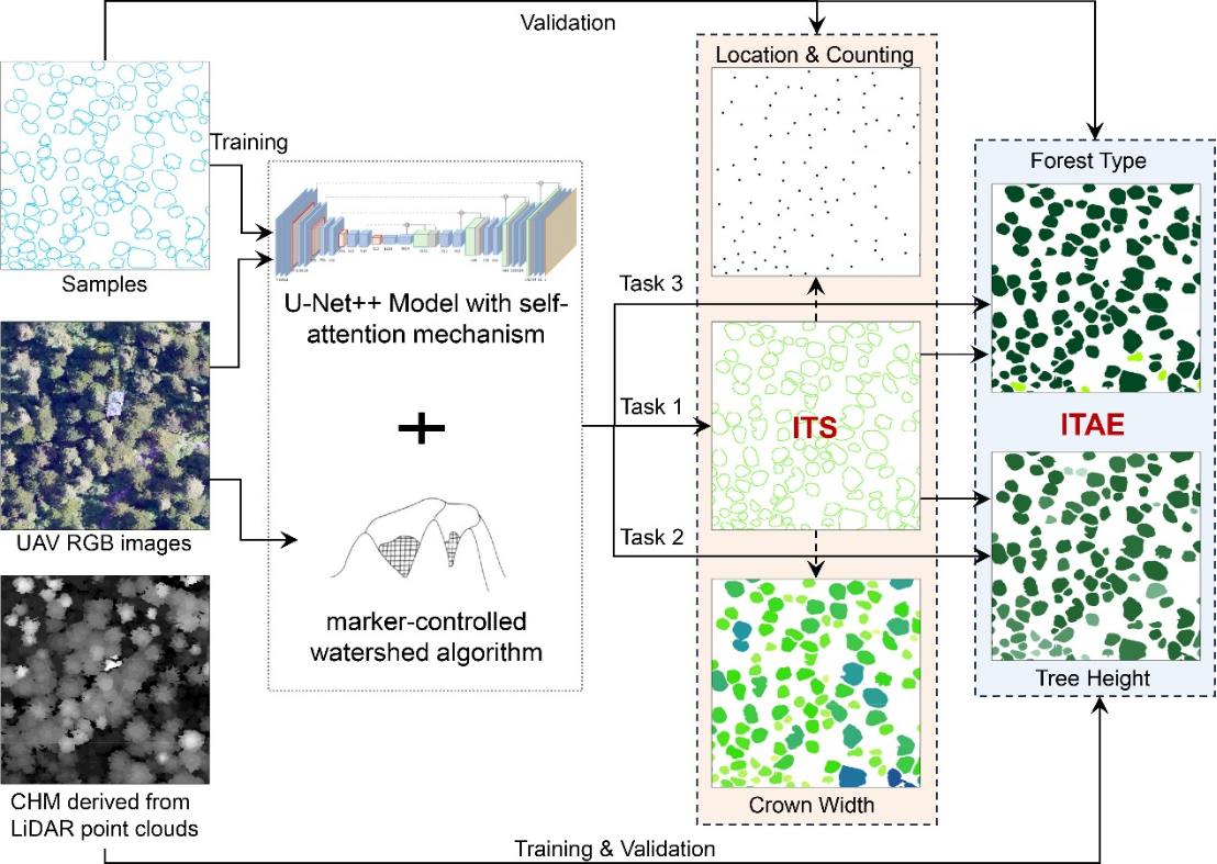
Workflow of the multi-task collaborative method for individual tree segmentation and multidimensional attribute extraction
(Image by LEI et al.,)
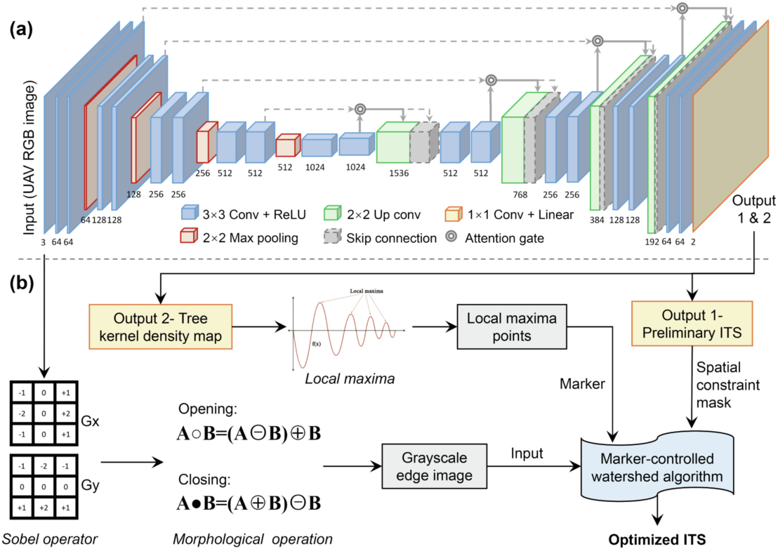
Architecture of the proposed two-stage ITS segmentation method (Image by LEI et al.,)

Spatial distribution of identified individual tree crowns across the 5 km × 5 km study area in WNNR (Image by LEI et al.,)
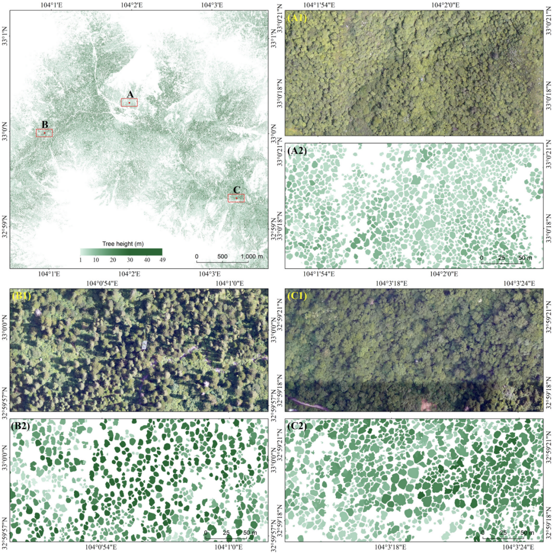
Spatial distribution of tree heights across the 5 km × 5 km study area in WNNR (Image by LEI et al.,)
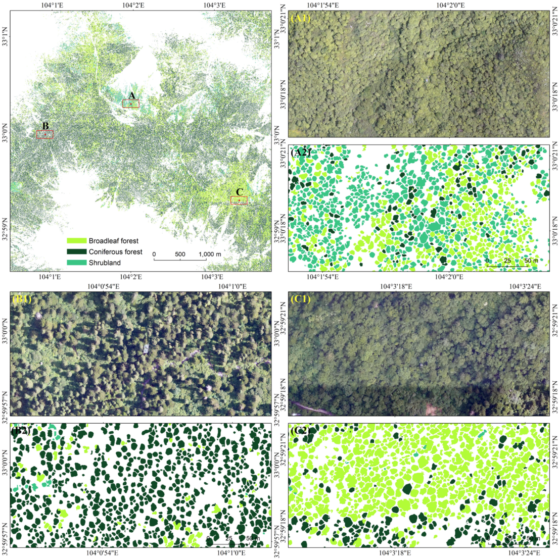
Spatial distribution of forest types across the 5 km × 5 km study area in WNNR (Image by LEI et al.,)